
Rebeico Copper-Gold
- Alaska Vein: high-grade gold and copper vein identified over 1.2 km strike. Maiden drilling in 2018 intersected grades up to 36.10 g/t Au & 5.95% Cu.
- New Year Zone: 2.2-hectare area with widespread gold and copper mineralization: samples up to 12.95 g/t Au and 0.65% Cu on surface. Maiden drill program commenced in Q1/20.
- IP Anomaly: sizable chargeability anomaly at depth identified from over 31.4-line-kilometres of geophysics.
- Target Delineation: Numerous historical and artisanal gold and copper workings identified for further evaluation within 100%-owned, 3,459-hectare land package.
- Catalysts: 2020 maiden drill program on New Year Zone, follow-up exploration on IP Anomaly, and regional exploration of expanded property package.
Property Overview
 The Rebeico property is located within the Sierra Madre Gold Belt, which has produced over 80.0 million ounces of gold and over 4.5 billion ounces of silver, plus significant amounts of copper and other base metals.
The Rebeico gold-copper project is comprised of 16 concessions totaling 3,459 hectares (Figure 1) on private land located in central Sonora, Mexico. The property is located 115 kilometres east of the city of Hermosillo which offers support to mining operations throughout Sonora. The property is accessible via Sonora State Highway 20 and a network of all-weather roads. Grid electrical power lines are within 6.5 kilometres of the property.
Rebeico Property Boundaries
 Ridgestone holds an undivided 100% interest in the property subject to a 2.0% net smelter return royalty (NSR), which can be reduced to a 1.0% NSR for US$1.0 million, and a 50% profit sharing agreement from commercial production up to a maximum of US$1.45 million.
History
Exploration on the Alaska vein (Figure 1) dates back to the late 1930’s based on mining claim records. Gold-copper-silver mineralization cropped out at surface, with underground development and production documented in the early 1940’s. Historically, ownership along the Alaska vein was fragmented. Several small underground mines were developed on the 1.2-kilometre length of the steeply dipping vein. These underground workings reached depths of 50 to 70 metres below the surface with several hundred metres of underground development. Smelter settlement records from the 1940’s indicate average mill grades of 20.2 g/t gold, 60 g/t silver, and 9.2% copper.
A number of artisanal workings have been documented by the Servicio Geológico Mexicano (“SGM”) within the nearby, western concessions now held by Ridgestone (Figure 1). Six artisanal workings were documented by the SGM to have high-grade copper and gold mineralization. In addition, the western concessions include the past-producing El Cobre mine, which was a high-grade underground copper mine operated by Asarco during the 1960’s. At El Cobre there was development on three levels each approximately 180 metres in length to a depth of 130 metres.
Modern exploration at Rebeico has included geologic mapping, sampling, ground geophysics (IP and Resistivity), and early-stage drilling by Ridgestone.
Regional Geology
The region of central Sonora surrounding the Rebeico project is within the southern part of the Basin and Range physiographic province of North America, transitional to the Sierra Madre Occidental province. Much of the region consists of northwest-trending block uplifts bounded by mainly northwest-striking normal faults. The oldest rocks in the vicinity of the project area consist of folded sequences of marine siltstone, sandstone, conglomerate and minor limestone of Ordovician to Permian ages that are unconformably overlain by thick sequences of interbedded andesite and andesitic volcanic-sedimentary rocks of the Upper Cretaceous Tarahumara Formation (Lopez and Cruz, 1996; Morales and Gastelum, 2006). These Paleozoic and Mesozoic rocks have been intruded over wide areas by composite stocks and dikes of monzonite, granite and granodiorite assigned by Morales and Gastelum (2006) to the Late Cretaceous-Paleocene period of Laramide batholith emplacement in northern Mexico. Peripheral to the project area, the Cretaceous-Paleocene and older rocks were unconformably overlain by rhyolite and andesite tuffs and flows of Oligocene age, and by polymictic conglomerate of the Miocene Báucarit Formation (Morales and Gastelum, 2006).
Property Geology and Mineralization – Alaska Area
The northern and eastern parts of the Alaska area are underlain by aphanitic to finely porphyritic andesite and intercalated volcanic-sedimentary rocks of the Tarahumara Formation (map unit KTsa). The Ordovician to Permian sedimentary sequence crops out south and southeast of the Alaska vein (map units Pzu, Pzc), where it has been folded into a series of WNW-trending anticlines and synclines, and has undergone contact metamorphism to hornfels.
In the southern and western parts of the Alaska area, the Tarahumara Formation and Ordovician to Permian rocks have been intruded by Late Cretaceous-Paleocene hornblende-biotite granodiorite, monzonite, and granite (map unit KTgd) of the regional batholith. These intrusions are medium-grained with mainly seriate textures. Throughout the Alaska area, the Cretaceous-Paleocene and older rocks have been intruded by generally narrow but aerially extensive dikes and sills of fine-grained aplite (map unit KTap).

UTM WGS84 projection; 20m contours, 500m grid lines. Hachured lines are unpaved roads. Quaternary surficial deposits in intermittent stream canyons have not been mapped. Blue lines are concession boundaries.
Two styles of mineralization have been recognized in the Alaska area of the Rebeico project:
- The tabular, moderately- to steeply-dipping Alaska vein with gold, copper and silver; and
- Gold-copper-silver in iron-oxide ± quartz cemented breccia and peripheral, fractured andesite (New Year Zone).
Alaska Vein
The Alaska vein has been traced for approximately 1.2km along strike and varies from about 0.5 to 2 metres in width, with a strike from N10E to N10W, and dips to the east at 45° to 75°. At and near the surface, and in the upper 50 metres of historical mine workings, it consists of variable mixtures of quartz, limonite, hematite, magnetite, pyrite, chrysacolla, malachite and azurite. Below about a depth of 50 to 60 metres, the Alaska vein is reported to contain chalcocite, chalcopyrite, bornite and native copper.
Summary of 2018 Alaska Vein Drill Program
In 2018, Ridgestone completed a 12-hole, 1,430-metre diamond drill program targeting shallow depths along about 500 metres of the Alaska vein. The program was successful in confirming the presence of high-grade gold and copper mineralization. Highlights from drilling included 1.53 metres grading 36.10 g/t gold plus 1.22% copper in hole 18REB10, 3.25 metres grading 8.31 g/t gold plus 2.41% copper in hole 18REB06, and 2.0 metres grading 8.69 g/t gold plus 2.78% copper in hole 18REB02. A summary of the 2018 drill-hole assay results is presented in Table 1.


Summary of 2018 Drill-hole Assay Results

New Year Zone
The New Year zone is located approximately 100 metres west of the southern end of the Alaska vein. Small outcrops of gossan and brecciated andesite ± quartz and magnetite are situated adjacent to a large dike of sericitized aplite.
In late 2019, Ridgestone completed a rock-chip sampling program over the New Year Zone to follow-up on historical reconnaissance sampling by Agnico Eagle Mines and YQ Gold. A total of 188 samples were collected in 2019 with an average weight of 4.5 kilograms. The program was successful in outlining an area of 125 metres by 175 metres (~2.2 hectares) characterized by widespread gold and copper ±silver mineralization at surface. Concentrations of bismuth are highly elevated and concentrations of lead, zinc, arsenic and antimony are low. Assay results are summarized in Table 2.
The geochemical signature suggests the New Year zone may represent a hydrothermal breccia pipe or small diatreme, possibly rooted in a porphyry intrusion at depth. The similar gold-silver-copper metal assemblage, with high bismuth and low lead and zinc, suggests the breccia mineralization and the nearby Alaska vein are likely related to each other and proximal to a center of magmatic-hydrothermal activity.
Summary of 2018 New Year Zone Sampling Program
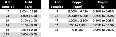
New Year Zone Sampling – Gold

New Year Zone Sampling – Copper

IP Anomaly
An Induced Polarization (IP) and Resistivity survey was carried out in 2018 & 2019 by Zonge International of Tucson, Arizona. The survey consisted of 15 east-west lines 200 metres apart that totalled 31.4 line-kilometres and covered an area of approximately 6.0 square kilometers.
The survey originated to the north of the Alaska vein, and provided 200-metre dipole-dipole coverage south through the New Year Zone and Elena concession. A summary report of the data provided by Zonge included 15 sets of IP and resistivity cross sections and horizontal slices at various elevations.
The Zonge report identified a pronounced high-chargeability feature which was encountered to the south and east of the Alaska vein at depths of 250 to 300 metres below surface, progressively increasing in width and intensity toward the south. This high-chargeability anomaly was identified over a total extent of 1,400 metres north-south and 800 metres east-west. The upper portion of the anomaly becomes progressively closer to the surface toward the south and is strongest beneath the Company’s Elena concession. Zonge also noted that a resistivity feature shows good correlation with the Alaska vein. Sampling of outcrops at the Elena concession has returned assays up to 3.77% Cu over 1.5 metres and 3.42% Cu over 1.5 metres
Chargeability Inversion Model Slice for 300 m Elevation at Elena

Copper Mineralization in Outcrops on the Elena Concession
